
I really enjoyed cruising through the forest. This trek seemed more intimate than others in that the trees had a stronger presence. Spruce trees dominated the area that otherwise would have been shared with Lodgepole Pines. Pine beetles and blight hadn't left their mark around here. Many streams had to be crossed all throughout the woods. The abundance of water helped fuel the kaleidoscopic explosion of color that surrounded me.


Half Moon trail had a trick up its sleeve though. Instead of the typical constant elevation gain seen on all other trails this one had something else in mind. The trail continued upwards until treeline where it began to wrap around and descend back into another valley.


The highest point around this area is Half Moon Pass at 11,640 feet. Past that and you can see where the trail leads down to East Cross Creek. The valley below made for nice views and sad knees.


The trail did a really good job of switching back and forth all the way down. It didn't deviate far from the fall line all the way to the valley floor. Interestingly, I couldn't help feeling like I was being watched during the whole descent. I had always wanted to see a mountain lion, but from a safe distance. I half expected to see one perched on top of a rock gazing down at me. Warily, I kept glancing all around for signs of a big purr monster. Nualla meanwhile was oblivious as she continued doing her favorite pastime of terrorizing squirrels. We managed to make it down to the bottom without incident. The area leading up to the creek was relatively flat and very wet. All the creeks that inundated the surrounding mountainsides came together in this flat area and created marshy wetlands. Mossy groundcover and lush green grass was everywhere. I saw some particularly unique groundcover in certain areas. It had flowers that seemed to be straining for the sunlight. This made for bean sprout looking stalks with little blooming white flowers. A stiff breeze would have done a number on these guys.

As I entered the marshy area of the valley earlier I took notice of mosquitoes milling about. Their numbers weren't out of control so I didn't think much of it. I had heard tale about campsites in this area and I began to see them as I cruised along. I wanted to stop and explore them for future prospects but the aerial antagonists had other plans in store. As I approached the campsites I unwittingly tripped the dinner bell alarm. Their numbers increased steadily at a disquieting rate. I couldn't help but think to myself, "You're out of your damn mind if you would ever want to camp here." This of course is an unfair assumption. I'm sure this area is downright pleasant when you aren't fighting nature during the height of skeeter season. Nearing the creek I saw remnants of yesteryear. I began to explore around, but tactfully so. One must be aware of the horde and walk with purpose, never stopping. This way you avoid the brunt of the onslaught. For my wanderings I only got two quick pictures.

 |
| East Cross Creek |


Any other soul would carry bug spray but my Chinese Zodiac sign is the Ox. I don't give much credence to these things but this admittedly sounds a lot like me. The rest of the familiar story consisted of me hauling ass up the trail until the kind winds protected me. In the safe zone I was able to take a breather and view the landscape around me. The usual marmot sentries announced my arrival.


I continued up the impressive ridgeline with the almighty cairn leading the way.


Ever vigilant, I took notice of the gathering clouds looming above as I neared the summit.


The cairns continued up the impressively built trail all the way to the final talus field.

 |
The view of Notch Mountain across the valley from the beginning of the talus field
|
 |
View in opposite direction
|
 |
Almost to the summit
|
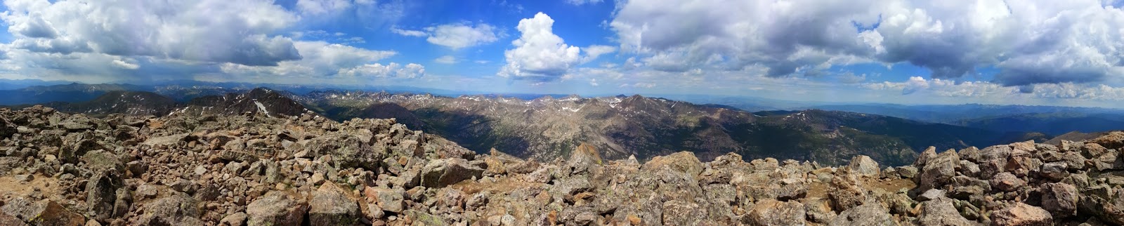
I got a nice view of the valley below when there was a break in the clouds.

Not much longer and I was looking around from the summit.
Between the clouds and mosquitoes I didn't waste much time getting back down the trail. I did make sure to take a couple of pictures of some flowers that stood out. In the second picture if you look carefully you can see how many little flowers there are dotting all throughout the grass.


I crossed the creek back to the other side of the valley and began my 970 foot ascent back up Half Moon Pass. I wasn't elated about having to climb back out of there but the promise of awesome views kept me going. Earlier in the day half of the valley was obscured in shadow and now the light was perfect. The second picture below is one of my favorites to date.


The clouds never ended up doing anything and I don't remember the mosquitoes being as bad on the way back out. The grass was greener on both sides and the glass was half full. My only other pictures taken on the way back to the trailhead was an out of focus one of some pink flowers and this Indian Paintbrush.

Once back at the car I made my way back down the rough road to Highway 24. 24 wound back and forth steadily climbing up through the mountains. I crossed tall bridges, passed abandoned ghost towns, all the while driving along the edges of rivers and cliffs. There is even abandoned Camp Hale where the 10th Mountain Division trained soldiers for winter warfare on mountainous terrain. After climbing over Tennessee Pass the final destination of Leadville was reached. If you ever end up in this area do yourself a favor and make the drive from Minturn to Leadville. Once in town I hung out around the grocery store killing time on the internet and updating my Instagram account. As the afternoon started turning into the evening I made my way over towards the Mount Massive trailhead. The trailheads for Elbert and Massive are right next to each other so I already had a handle on the area. I went back to the same spot where Jesse and I posted up before Elbert. As fate would have it there was already a fellow dirtbag car camping there. Throwing down money for a bonafide campsite was out of the question so I made nice and introduced myself. There was plenty of room for another car so I wasn't worried about stepping on toes. The other vehicle was an older subaru wagon with a roof cargo box and Montana plates. Come to find out the fellow traveler was sharing a similar adventure. I wanted to stay sociable and friendly but careful not to pry. About all he offered was that he only made it halfway up Elbert before having to turn around. He went on to mention that he really needed to lose some weight but wasn't making any progress. I tried to cheer him up but he seemed genuinely sad, crestfallen at his lack of improvement. I felt compelled to pull him out of his slump but he kept to himself and didn't surface again after retiring to his car. You can't win 'em all.
I love your descriptions and also love the fact that you stopped to snap photos of the flowers. I do not love mosquitoes. quit being sofa king stubborn! xoxox
ReplyDeleteStubborn? NO!....no No NO!!
ReplyDelete